New Toolset Enables Fire Managers to Confidently Use Fire Weather Forecasts
Clients
Joint Fire Science Program (JFSP)
USDA Forest Service
Fire weather forecasters, fire planners, and fire management decision makers must have easy ways to assess the quality of weather forecasts to predict when and where fires will ignite. In collaboration with the USDA Forest Service AirFire Team and with funding from the Joint Fire Science Program, Sonoma Technology developed an intuitive system that produces easily understandable, meteorology-based fire weather forecast assessments.
<br>
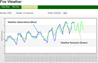
The Fire Weather Prediction Accuracy Assessment System (FWPAAS) provides real-time information about meteorological model bias, model reliability, and overall performance of fire weather forecasts. Specifically, the FWPAAS enables users to
<ul>
<li>Assess fire weather forecast reliability by comparing forecasted weather parameters with observations at remote automated weather stations and automated weather observation system weather stations</li>
<li>Assess fuel quantity and continuity across spatial landscapes using Fuel Characteristic Classification System fuelbeds, National Fire Danger Rating System fuel models, and the 40 Scott and Burgan fire behavior fuel models</li>
<li>Assess spatial variability in current and forecasted fuel moisture and fire ignition potentials using the National Fire Danger Rating System and the Canadian Forest Fire Danger Rating System</li>
<li>Support strategic placement of fire suppression forces</li>
<li>Support strategic decisions for managing ongoing wildfires</li>
<li>Support go and no-go decisions for igniting prescribed fires</li>
Fire and Smoke
Forecasting
Meteorology
Software Development


Kenneth J. Craig

Kenneth
J.
Craig
Manager, Atmospheric and Emissions Modeling Group / Principal Scientist
kcraig@sonomatech.com
/sites/default/files/2023-02/KJCres.pdf
