Accurate Mapping of Daily and Sub-Daily Wildfire Growth Using Satellite Observations
Clients
Pacific Gas & Electric
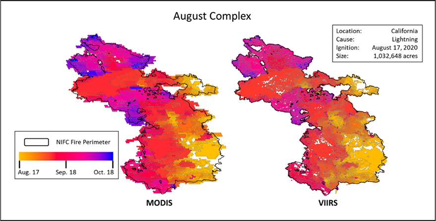
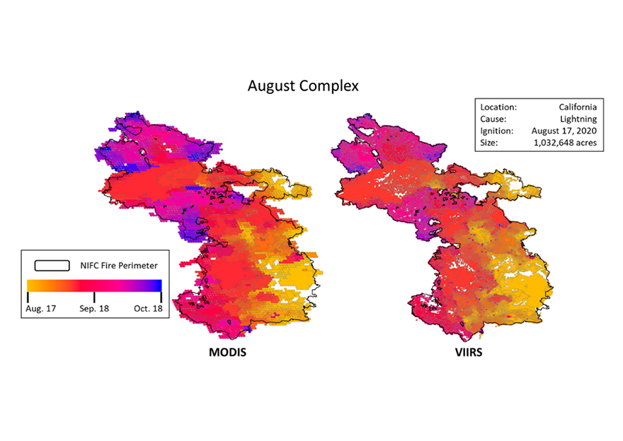
Fire research and management applications, such as fire behavior analysis and emissions modeling, require consistent, highly resolved spatiotemporal information on the progression of wildfire growth. Sonoma Technology developed a new fire mapping method that uses quality-assured sub-daily active fire/thermal anomaly satellite retrievals (2003-2020 MODIS and 2012-2020 VIIRS data) to develop a high-resolution wildfire growth dataset. This dataset includes growth areas, perimeters, and cross-referenced fire information from agency reports. Satellite fire detections were buffered using a historical pixel-to-fire size relationship, then grouped spatiotemporally into individual fire events. Sub-daily and daily growth areas and perimeters were calculated for each fire event. After assembly, fire event characteristics, including location, size, and date, were merged with agency records to create a cross-referenced dataset. Our satellite-based total fire size shows excellent agreement with agency records for MODIS (R2 = 0.95) and VIIRS (R2 = 0.97). VIIRS-based estimates show an improvement over MODIS for fires with areas less than 4,047 hectares (10,000 acres).
<br>
The novel spatiotemporal resolution and methodological consistency of our dataset enables advances in applications related to historical fire-weather analysis, fire-weather modeling, characterizing wildfire growth potential, historical/future smoke modeling, and near-real-time fire monitoring. We are currently incorporating fire detection data from geostationary satellites in the method to derive hourly fire growth information.
<br>
This work is published in the <a href="https://doi.org/10.1071/WF22048" target="_blank">International Journal of Wildland Fire</a href>.
<br>
The novel spatiotemporal resolution and methodological consistency of our dataset enables advances in applications related to historical fire-weather analysis, fire-weather modeling, characterizing wildfire growth potential, historical/future smoke modeling, and near-real-time fire monitoring. We are currently incorporating fire detection data from geostationary satellites in the method to derive hourly fire growth information.
<br>
This work is published in the <a href="https://doi.org/10.1071/WF22048" target="_blank">International Journal of Wildland Fire</a href>.
Air Quality
Fire and Smoke
Modeling


Crystal D. McClure

Crystal
D.
McClure
Senior Atmospheric Data Scientist
cMcClure@sonomatech.com
/sites/default/files/2025-03/CDMres.pdf
