
Integrating Satellite Data and Ground Reports to Identify Fire Locations
Clients
U.S. Environmental Protection Agency (EPA)
USDA Forest Service
Ministry of the Environment, British Columbia (Canada)
National Aeronautics and Space Administration (NASA)
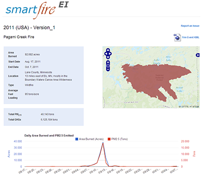
Historically, information about fire locations and areas burned has been collected in a variety of ways by different agencies. As a result, this information has become decentralized and is difficult to acquire. The SmartFire system, developed by Sonoma Technology in collaboration with USDA Forest Service researchers, is an algorithm and database system that operates within a GIS framework. SmartFire combines multiple sources of fire information and reconciles them into a unified GIS database. It reconciles fire data from space-borne sensors, aircraft reconnaissance, and ground-based reports. SmartFire products include fire locations and area-burned estimates.
<br>
SmartFire is helping fire, smoke, and air quality managers easily
<ul>
<li>Include the most complete fire information in real-time smoke forecasting systems, such as BlueSky</li>
<li>Access and view daily fire locations and area burned estimates</li>
<li>Acquire fire location and area-burned information for post analyses of fire spread and emission inventory development</li>
Fire and Smoke
Software Development

Crystal D. McClure

Crystal
D.
McClure
Senior Atmospheric Data Scientist
cMcClure@sonomatech.com
/sites/default/files/2025-03/CDMres.pdf